
This was the second paper that looked at previous surveying revolutions, then went on to look at the current revolution.
The Surveying Revolution of 1550-1650: Implications for the Current Geospatial Revolution — Part II
Abstract
In a previous paper (Hazelton, 2012), the Surveying Revolution of 1550-1650 was discussed. This discussion is continued in this paper, with an attempt to find parallels between that revolution and the current Geospatial Revolution that started around 1950. The current revolution should be considered the fourth revolution, and it has stronger parallels to the third, especially with regard to timing, than the first two.
The critical point of revolutions has little to do with technology, methods and theory, than with how people see their world, i.e., how they think. The hunter-gatherer society had no conception of the life of a farmer, and little social structure to deal with having to change to that lifestyle. Similarly, the arrival of industrial society was extremely difficult for the agriculturally oriented people involved: Blake’s apparent description of early factories as “these dark Satanic Mills” was not an idle poetic construction. Today, as the Industrial Age changes into something else, our thinking is often stuck in what worked for the Industrial Age, not for the current situation. This is not surprising, because we have little other experience. As Industrial Age institutions become increasingly dysfunctional in new circumstances, Industrial Age thinking will not fix things.
While the nature of a new geospatial worldview cannot be discerned at present, there are indications about some of the important attributes of what might drive that worldview. These are presented and discussed in this paper.
Introduction
“For the roots of the present lie deep in the past, and nothing in the past is dead to the man who would learn how the present comes to be what it is.” (Stubbs, 1903, p. iv)
There have been several surveying revolutions through history. The first was the creation of surveying, as an arm of the religious orders of early societies that needed to deal with taxes, land ownership and the general good order of society. This role allowed surveying to be a key part of the shift from a Neolithic culture to agricultural and artisanal societies. Notice the connection between the development of a very specific discipline and changes in society.
The second occurred over several centuries as the Ancient Greek approach to mathematics via geometry was driven, in part, by surveying issues. The codification of geometry allowed surveying to move forward with a sound foundation for solving spatial problems. Ancient Greek culture introduced many major shifts in how a civilization should operate, and surveying was part of these shifts, tied up in the Ancient Greek worldview of comprehension through ordered knowledge.
The third revolution occurred during the period 1550–1650 AD. There was a flourishing of technology, which led to new techniques, followed by a new worldview. The revolution in surveying was rapid and complete, with little of the previous worldview and equipment remaining after the revolution, and indeed, even halfway through it. The problems that this surveying revolution uncovered, especially in geodesy, provided a major impetus to mathematics into the 19th century.
A fourth revolution started with new technology after World War II, around 1950. The rate of change in technology and techniques has been accelerating and relentless. But just as in previous revolutions, there has been a critical, short period where the changes have been more than just technology and technique. The better, faster, cheaper period of change shifts to create much more fundamental change. That period happened in the third revolution from about 1612 to 1620, when the theory, technology and techniques for a total change in worldview came together. The equivalent period in the current revolution would be about 2012 to 2020.
The obvious questions are: What are the changes in worldview that the discipline will experience? What will that mean for the discipline and the people currently in it?
Predicting the future is fraught with failures, but some suggestions of the big changes would be as follows. The collection of massive amounts of spatial data rapidly and with relatively high precision, as well as at relatively low cost, is one major technological change. Billion-fold productivity increases in data collection over a period of less than 20 years is a major game-changer. How can we deal with this quantity of data?
The spread of spatial data collection and processing capabilities to the larger society, creating new data collectors and creators, as well as new consumers, is another major change. Coupled with the de-personalization of measurement, which is mediated more and more by machines, and measurement is increasingly remote from human interaction. This is a major threat to those who define the discipline and themselves as solely concerned with ‘measurers’ and ‘data collectors,’ and they miss the opportunities for working with this huge new market.
At present the developed world is in some turmoil, as the various systems that were developed to support the industrial society that came from the Industrial Revolution become progressively dysfunctional. This is because the industrial society and the associated industrial economy is disappearing in the same way that the agricultural society and the associated agricultural economy disappeared during the Industrial Revolution. In the US today, less than 25% of the national economy, in dollar terms, comes from primary and secondary industry, i.e., agriculture, mining and manufacturing. In much the same way that the Industrial Revolution could not be understood as it was starting, the current changes are too early in their development to be fully understood.
There are, however, a number of certainties that have lasted through previous revolutions. People still need to eat and live somewhere. Land is still needed to live on and grow food on. At more complex levels of society, information about where things are located will always be needed, and the more complex that society is, the more complex its information needs, and the more important the quality and reliability of the resulting information.
While civilization exists with any form of order, there will be a need for reliable information to manage it. Many of the dystopian visions of the future of the world overlook the fact that the information required for these worlds to exist needs to be processed, not just gathered, and the first step in the processing is selection, structuring and transformation, together with the assumption of quality and reliability. Without this, it’s just noise: not data, nor information nor anything that can be used for management of the real world. Without a guarantee of quality, taking action on the basis of the information is extremely risky, as poor information can be much more dangerous than no information. Not all of this can be handed off to machines, so there will always be a role for the spatial data experts. Finally, a totalitarian state cannot exist indefinitely, because it must collapse owing to its own deep contradictions concerning strength and fear.
At the ‘completion’ of the current geospatial revolution, surveying will be almost unrecognizable, just as during the third revolution. If a Roman surveyor from 300 AD were to be suddenly dropped into 1400 AD, he would not notice much change in techniques, technology or worldview. But drop him at 1650 AD, and there would be nothing recognizable, not even techniques or worldview. It will be the same in this revolution, but just because something has changed beyond recognition, does not mean that it has disappeared. The Roman surveyor could not project his understanding forward through changes he could not comprehend, but it is much simpler to look back with the advantage of understanding both old and new. We can see what has stayed the same, and what has changed, and understand why. Similarly, we cannot see the consequences of technological developments that have not yet been made in this revolution.
The essentials of the surveying that built the pyramids and re-surveyed the plots of land after the annual flooding of the Nile, 4,500 years ago, are with us today, and will still be with us in a hundred years’ time.
But what will surveying, geomatics and the geospatial discipline look like and be called after this revolution? We don’t know, but based on every previous revolution, things will be very different and much bigger than before the revolution. Hang on, because it’s going to be quite a ride!
Disruptive Technologies vs Sustaining Technologies
Christensen (1997) analyzed a range of industries that had experienced major technological changes that had led to the failure of major companies, looking for how the technological change had occurred and how it had effected the industry in which it was occurring. The industries he discussed included computer hard drives, steel manufacturing, and excavator manufacturing. What was interesting was the nature of technological change that different companies were involved in.
Many of the well-established companies in an industry were often heavily invested in technological development and innovation, but their focus was on improving the efficiency with which the existing customer base was serviced. In most cases, the companies were pursuing the top end of customers, where profit margins were higher, so their emphasis was on improving efficiency, and so profits, at this end of the market. Christensen describes this as ‘sustaining technology.’ In a number of cases, the technological change that led to the company’s downfall was presented to the company, or even invented there, but was rejected because it dealt with the thin margins at the bottom of the market when it was first developed.
However, these ‘disruptive technologies’ were able to accelerate their rate of development, while keeping their thinner margins, and slowly undercut the established companies as the technology rapidly grew in capabilities to take over the top end. What led to the downfall of the established companies was that they suddenly discovered they had a major competitor with significantly lower prices, and if they attempted to compete on price, they had to cut income to the point where they could neither afford to innovate nor overhaul their infrastructure. At this point, their downfall was almost assured.
Christensen’s ‘Innovator’s Dilemma’ is that disruptive technology cannot succeed in an established company, because it cannot offer the profitability of established technologies, which sustain the organization’s current form. The disruptive technology usually has to create a new structure to develop, and the established companies do not see it as a threat because they cannot see how it would be sufficiently profitable. In many cases, where the disruptive technology starts is by taking the low-margin, bottom-end customers that established businesses feel they can afford to lose because they provide little profit. When the new technologic companies are finally perceived as a threat, it is usually too late.
In the geospatial area, the disruptive technologies have been computerization, networks and image-based systems. These technologies slowly developed almost behind the scenes of the rapidly increasing efficiency of point measurement. Dismissed by many as irrelevant to ‘serious’ measurement, they now threaten to reduce ‘serious’ measurement to a niche activity. When you have an on-line database with trillions of spatio-temporal points, why do you need to ‘measure’ anything?
Ways of Thinking
“We are what we think.
All that we are arises from our thoughts.
With our thoughts we make the world.”
Gautama Buddha
How we think about a situation affects how we can deal with it. If our thinking is limited to what we already know, then we cannot recognize new situations. We risk interpreting them as something other than what they are. In our desperation to understand, we reach for quick and simple labels, adopt them and think we have solved the problem, because the act of labeling also becomes the act of deciding. Then we emotionally defend our decision. For example, in political debate we are faced with an economic system based on an Industrial Age and economy that is becoming increasingly dysfunctional in a non-Industrial Age and economy. How do we deal with this thing we have never seen before? We grab labels like ‘liberal’ and ‘conservative,’ even ‘the 800 lb. gorilla in the room,’ slap them on particular people and ideas and feel we have solved the problem. But we have simply allowed the situation to grow worse by debating irrelevancies.
What irrelevancies are we pursuing in trying to come to terms with this geospatial revolution? How are we characterizing it that may be leading us astray? Those are questions we must all consider in our own hearts and minds. Perhaps prior experience, even going back millennia, can help us understand some of what is happening.
Between the Revolutions
The period 1650-1950 was hardly a lull in the development of surveying and mapping. The rate of change was slower than 1550-1650 and change was incremental, but critical developments were made. A significant amount of statistical theory, especially regarding errors, was developed from the work of Delambre and Méchain on the survey of the Paris meridian 1792-1799, leading to the development of least squares adjustment by Gauss, Legrange, Legendre, Laplace and others (Alder, 2002). Newton and Leibnitz developed differential and integral calculus. Instruments and computational methods improved, and geodesy was a major driver of mathematical development until the early 19th century (Alexander, 2010). New map projections were developed, the problem of determining time and hence longitude was resolved, and the telegraph introduced the first ‘Internet’ to the world, together with co-ordinated timing.
During those three centuries, however, the fundamental ideas and methods of surveying remained largely intact. Instruments improved, rather than undergoing total change. Methods were refined and advanced, rather than totally overturned. Change was constant, but steady and consistent. The revolutionary days of 1550-1650, when everything had been overthrown and replaced, were safely in the past. Reviewing the history of surveying only for the period 1650-1950 would lull one into a false sense of stability in surveying.
Even arrival of the Industrial Revolution, beginning around 1750, made relatively little impact on how surveying was done. Industrial technology allowed improvements in surveying instruments, but triangulation was the key geodetic technology, while traversing increased in importance for local surveys as distance measurement equipment improved. Industrialization pushed a need for more surveying, but the work was along similar lines to that practiced for many years.
During the period 1650-1950, the main emphasis was on the ‘better, faster, cheaper’ mantra. Equipment improved, but incrementally. Wild’s T2 theodolite was a marked improvement on previous instruments, but it still only turned angles. Rods gave way to chains and then tapes and bands, and finally invar tapes allowed very high precision taping, but the process of distance measurement remained much the same. Levels improved and evolved, allowing automatic leveling of the line of sight, and micrometer reading of the leveling rod, but the process of leveling remained much the same. Plane table topographic surveys became more efficient as the triangulation network grew and provided plenty of visible control points, but otherwise changed little. Industrial efficiency allowed the price of equipment to drop, thereby making it more widely available, but the process of surveying remained much the same. The technology changes that occurred in surveying equipment and procedures during this period were largely what could be described as ‘sustaining.’
In essence, surveying remained a process by which the real world was broken down into a small subset of objects that allowed straightforward measurement. Surveying was concerned with defining boundaries, the points of change, whether these were ownership boundaries, attribute boundaries or slope boundaries. In a largely 2-D representation of reality, these boundaries were lines, which were broken down again to a string of points. Measurements were made to these points and were largely based on the measurement of angles, distances and elevation differences. This approach, focused on the measurements, involved primarily an analytical thinking approach: things are broken down into simpler pieces for further consideration.
Surveying focused on measurement because measurement was physically difficult. Equipment was pushed to its limits to get the precision required to deal with on-going issues, e.g., the arc length of meridians. Reading the stories of the great 19th century surveying efforts, such as the triangulation in Ecuador (Ferreiro, 2011), the Great Triangulation Arc of India (Keay, 2000), and the work of Len Beadell in the 20th century (Beadell, 1966) indicates the monumental cost of this measurement work in terms of lives, injuries and health destroyed. So it is not surprising that there is a strong focus on ‘measurement.’
During long periods of slow incremental change, there is no driving need for major changes in thinking and technology. Technology can be slowly improved, but radical changes rarely occur. As a consequence, there is no need for a major change in how people think about the technology, or how they use it, so thinking tends to get solidified in particular directions. Changes in use are incremental.
For surveying in particular, the emphasis on measurement meant that the thinking involved was almost completely analytical. Technological change did not take people very far from the fundamentals of measurement, so there was no need to shift thinking to a different style. Problems that arose, such as dealing with errors, could be dealt with by breaking the problem down into smaller pieces, each of which could be dealt with individually. Thinking that integrated concepts across the panoply of measurement technologies and approaches was far less common than thinking that burrowed into individual concepts and explored them in more detail.
Synthetic thinking, thinking that integrates pieces, is far more difficult than analytical thinking, which breaks things down into pieces. Yet in rapidly changing times, analytical thinking cannot operate as effectively, because the background of things to recognize and work from are absent or disguised. Synthesis often requires creative problem solving and constructive thinking.
The Current Geospatial Revolution, c. 1950–?
The first hint of a disruptive technology appeared in 1849, when Laussedat (the ‘Father of Photogrammetry’) took architectural photographs for the purpose of measurement. In 1858-59 Bertaud’s ‘Objective’ and Brunner’s ‘Camera-Box plus theodolite attached to side’ were being used to produce the first contour plan from photographs. By 1873 Jordon and Finsterwalder were producing maps from photographs, and the fundamentals ideas and methods of photogrammetry had been formulated (Werner, June, 1968, p. 137). Photogrammetry is a fundamentally different measurement technology, and it was a harbinger of what was to follow some 150 years later.
The mass of technology developed for two World Wars in the 20th century had a significant impact on surveying and mapping. WWI brought major advances in optics, especially refinement of lenses. After WWI, the rapid development of aircraft enabled significant advances in aerial photogrammetry, although the main applications came after WWII, when aircraft were more widely available. WWII brought radar as a distance measurement system, which led to the development of the Tellurometer in South Africa in 1954, followed by Aerodist. The creation of the Geodimeter in Sweden in 1943 allowed distance measurement using the visible and infrared parts of the spectrum (Werner, June, 1968). Radio location systems developed in WWII led to LORAN, OMEGA and GNSS.
After WWII, electronic computing devices started to become more available, allowing larger computations to be undertaken. As electronics became miniaturized, they were fitted to more and more measurement devices, changing the way that measurements were made. In 1968, Zeiss introduced the ELTA 46 (ELTA from ‘ELectronic TAcheometer’), the first total station, which combined electronic distance measurement with electronic circle reading, and allowed some on-board calculation and electronic data recording (usually to punched paper tape). Other manufacturers followed suit, with Hewlett Packard’s instrument name, ‘total station,’ sticking to this class of instrument.
Satellite positioning systems were introduced in 1964 when the Transit Doppler system (also known as NAVSTAR) became operational, culminating in today’s GNSS. These systems are computationally intensive, but can provide global location to the millimeter level through the use of paired receivers.
To this point of development, the fundamental approach to surveying had not changed. The world was measured by carefully selecting and measuring individual points to represent some larger set of objects. Each measured point had to be visited and measured individually, even though the technology enabled this to be done better, faster and cheaper with every passing year. Total stations and GPS still required each point to be visited (even if remotely with a reflectorless total station).
The technological exception was photogrammetry, which allowed a very large number of points to be measured remotely and simultaneously with a camera. The development of laser scanners and LiDAR, as well as digital photography and remote sensing, continued this process of collecting extremely large numbers of points or pixels very rapidly, thus becoming cheaper, faster and easier.
Photogrammetry was the first disruptive geospatial technology of the current geospatial revolution. Initially is seemed expensive to implement: you had to develop plates from a terrestrial camera, process the images in some kind of plotting device and then get the map, rather than the direct field mapping of the plane table. For aerial work, there was the cost of the aircraft and camera, as well as all the subsequent processing. Computers sped a lot of this up, first slowly, then more rapidly as digital/softcopy photogrammetry arrived. LiDAR and remote sensing followed, building on photogrammetry’s foundation.
The result of these latest changes is that the way surveying is done is being changed in fundamental ways. The essential point is that the ‘intelligence’ and ‘meaning’ of a measurement are not being recorded at the time of measurement. Traditionally surveying measurement was slow enough for these components to be recorded at the time of measurement. Modern measurement systems (laser scanners and LiDAR, photography, remote sensing) defer this stage of the process, and so ‘meaning’ and ‘intelligence’ must be added later. The trade-off is the rate of data collection of modern measurement systems, which may be up to eight orders of magnitude faster with an array of mobile laser scanners, compared to data collection using total stations.
While this paper does not provide a discussion of larger societal issues, it should be noted that the western world has been moving into a post-industrial society and economy since the 1950s, and that these changes, from an industrial- and manufacturing-based economy to one based on information and services, are having widespread effects on western society. Political and economic changes since the 1950s have been dramatic, as have changes within society, as may be seen by the changes in the general state of the ‘family’ over the past 50-60 years.
In summary, there is a new surveying revolution under way. It started around 1950, as the technology from the two World Wars became widely available and began to be integrated into regular work. There was a definite acceleration of development from the end of the 19th century, but the real rush of new technology and techniques started around 1950. This revolution has expanded to create new disciplines, which have required the development of new names, such as geomatics and geospatial science. So the current revolution is a geospatial revolution, rather than just a surveying revolution.
The first 50 years of this revolution has been largely concerned with using traditional methods (fundamentally, point location), but making them better, faster, cheaper and easier. Along the way, many older methods have fallen into disuse, such as triangulation and optical tacheometry. But the essential concept of data collection remains: one carefully selected point at a time, with careful assessment of the meaning and intelligence of each point included with the measurements.
The advent of technologies that omit the meaning and intelligence with each point observation, but provide massive quantities of point data in exchange, are one of the primary driver of revolutionary change in the second stage of the revolution. These technologies and their related techniques are driving, and will continue to drive, the major revolutionary changes after 2000 AD.
Discussion
Looking at the speed of adoption of new technology in the current geospatial revolution, it can be seen that the theodolite and transit have been largely abandoned for total stations, that GNSS is in widespread and regular use, that airborne LiDAR is starting to become more widely used, and that terrestrial laser scanning is finding a wide range of suitable applications. GIS is becoming a key technology for a number of surveying organizations, as it becomes required for plat submission in a number of jurisdictions. Information about these technologies is spreading through trade journals and conferences, as well as among professionals.
While the US surveying profession has been slower than much of the rest of the developed world in widespread adoption of these technologies, it is catching up. Further, the time lag is small in the larger scale of historical time. Areas that still need to be addressed in the US are techniques and background theory for the new technologies, as well as the ability to move with the coming rapid changes in theoretical fundamentals.
The speed of technological adoption in the current revolution has produced something close to a complete change in equipment and methodologies over the past 50 to 60 years, and there have been significant changes in the supporting level of technological and theoretical knowledge among practitioners. Comparing this to the first 50 to 60 years of the 1550-1650 revolution, it can be seen that the technology of the day was moving into wider use, that techniques were changing and these changes were supported by early textbooks. The process of change may have been quantitatively slower, but the rate of dissemination of ideas was comparable.
The real changes started after the first 50 to 60 years of the 1550-1650 revolution. Technology had improved, but the big jump was after 1600 to 1610. The extension of triangulation and the development of resection, together with far more advanced computational tools, allowed survey control to extend across continents and link isolated plane table topographic surveys together into national mapping efforts. The second half of the 1550-1650 revolution was the time when the real changes took hold and created the real revolution in the fundamentals of surveying.
As an example of the speed of change, Snell introduced his developments in triangulation in 1612-1615, Napier developed a working system of logarithms in 1614, Rathborne advocated the use of logarithms and trigonometric tables in surveying computations in his textbook of 1616 (along with traverses and the tripod), and the slide rule was developed in 1620. A mere eight years saw development of the primary method of extending survey control across the continents, the development of the fundamental computational tools to support this work, and a textbook urging the adoption of these new technologies and techniques. Perhaps no other eight-year period in the history of surveying has seen the introduction of such collectively disruptive technologies and techniques.
The same process can be seen at work in the current revolution. The first 50 to 60 years consist of technological developments that introduce some changes (e.g., electronic total stations) and some significant innovations (e.g., GPS). But the procedures are still ‘one point at a time.’ After around 2000, these earlier developments are subsumed into the truly revolutionary changes being wrought by digital photogrammetry, laser scanners and LiDAR, satellite imagery, and the Internet with its communication, storage and computational capabilities, together with ubiquitous image capture, computation and positioning.
In the current geospatial revolution, the following processes can be seen:
- A slow build-up of various technologies in parallel (EDM, GPS, photogrammetry and remote sensing, GIS, digital computing), then the introduction of a small number of integrated technological changes in a short period of time (fast and ubiquitous Internet, digital photogrammetry, laser scanners), creating a ‘tipping point,’ followed by a rapid series of fundamental changes (ubiquitous spatial measurement, shift in meaning and intelligence in measurement, massive integration), transforming the entire geospatial discipline;
- Complete change or transformation, across the entire discipline, once the technological tipping point was reached (this process is just getting started in this fourth revolution);
- An initially accelerating rate of change (prior to 2000), followed by the rapid transformation of the discipline (post-2000) after reaching the tipping point (2000-2010);
- Key technologies that together with larger societal change are driving fundamental transformations in the discipline.
In the current geospatial revolution, the combination of advanced and ubiquitous measurement technologies, instant broadband communication, and technologies for integration and analysis of spatial information, together with changes in political, economic and social systems, are driving widespread spatial data creation, communication and use, changes in the nature of knowledge and learning, separation of surveying into multiple geospatial disciplines, and a totally changed role and mindset for practitioners in the geospatial disciplines.
Parallels between the two revolutions are discernible. This allows some of the lessons from the 1550-1650 surveying revolution to be applied to the current geospatial revolution. The implications of following general parallel paths through each revolution are that some reasonable effort can be made to discern the deeper fundamental changes coming to the geospatial disciplines.
The changes occurring are creating a new foundation in the geospatial sciences, so current and future generations can attempt work that could not be imagined before 1950, and possibly could not be done before about 2000. The possibilities keep expanding, limited only by human imagination and ingenuity.
Looking Ahead
There are several major changes that are descending upon surveying and the wider geospatial disciplines. These will play out over the next few decades, but these changes will go deeper than anything since 1950. They will strike at the heart of surveying in particular and the geospatial sciences in general. Some of these will be dealt with in detail in subsequent publications, but a brief summary is in order here.
This author suggests that there are or will be at least seven areas of major change. These all flow from the changes in technology, and hence techniques, that are happening both within the geospatial disciplines, and across the world.
This list is not designed to be a set of predictions, more a set of indicators about where the most probable areas of change will occur. In many cases they are obvious extensions of current trends or obvious places where there are holes in basic theory and techniques.
- Shift from measurement to management
With the ubiquity and rapidly declining cost of spatial measurement technology, measurement data becomes a form of commodity. An economic characteristic is that margins on commodities tend towards zero, which means that there is very little profit in general measurement itself. This can be seen already as the incremental cost per point of modern measurement technologies is, effectively, zero. Therefore, to attempt to secure a monopoly over spatial measurement would make about as much sense as trying to secure a monopoly over seawater.
There will still be needs for specific sets of measurements that must be done by experts, but the bulk of measurements will become aggregated and distributed at a cost that is approaching zero. This is part of general spatial measurement becoming a commodity. What matters today, and more so in the future, is the value that is added to the spatial measurements as they are used to meet client needs, the value that expert problem solvers add. This broad trend can be characterized as a movement from measurement to management.
For example, leveling is becoming more specialized. We no longer need to do large-scale topographic leveling, because airborne LiDAR does it more cheaply. UAVs and digital photogrammetry can also do it more cheaply. For construction, we use more RTK GNSS, or the foreman has a construction level set up in the one spot all day. We do leveling for control and specialized work. Topographic leveling, where we once produced lots of leveled points across the terrain, is now becoming a commodity and traditional leveling cannot compete, except in special applications.
While a significant part of spatial data management will be integration and aggregation, it will be necessary to move into management based on spatial information and knowledge, as well as management of spatial information and knowledge itself. By building on existing areas of expertise within the geospatial disciplines, areas such as land management, property rights management, planning, and related fields have lower barriers to entry for geospatial groups seeking to expand their offerings and skills.
There has been a global trend towards land management for surveyors for many years, and a significant part of the original meaning of the term ‘surveyor’ in English is that of a land manager or overseer, rather than a land measurer, as in Fitzherbert’s 1523 surveying textbook. Land management remains a key role for English surveyors. This global trend will continue.
- Shift in where ‘meaning’ and ‘intelligence’ are included in the measurement process
One of the major changes in measurement that has occurred over the past 100 years is a shift in where ‘meaning’ and ‘intelligence’ are added to the raw measurements. Traditional surveying measurements incorporate meaning (what does this point represent?) and intelligence (how does this point fit into the larger scheme of things?) at the time of measurement. Since each point must be physically visited, there is time to make the meaning and intelligence explicit. One obvious outcome is that a well-recorded survey can be converted to a formal plan or map from the field notes alone.
Modern surveying technologies defer determination of meaning and intelligence, and focus on making measurement as fast as possible. This has led to something close to a billion-fold increase in measurement speed, at the cost of deferring determination of meaning and intelligence. The increase in the number of points collected means that more powerful tools can be used to provide a degree of automation for determining meaning and intelligence, and large numbers of points can be dealt with simultaneously, but there is still much development to be done to speed up these processes.
In photogrammetry, we used to think that we were doing measurement when we ran the plotter. The reality is that all the measurement was done at the moment of exposure of the film. We were just making the ‘meaning’ and ‘intelligence’ explicit, and plotting it on a map.
A positive side effect of this change is that the source of the data is much less important, provided there are available measures of its quality. This enables much wider integration of data.
- Radical changes in statistical theory and least squares adjustment
The statistics that forms a foundation for serious analytical work in the geospatial disciplines is based on two sub-fields: descriptive statistics and inferential statistics. Descriptive statistics is straightforward and unlikely to change much, but inferential statistics is heading for a major set of changes.
Traditionally, measurement data produced a small sample from a large or infinite population of possible measurements. Inferential statistics is based on using very small samples to infer patterns in populations. Today, very large sample sets can be gathered, which render ‘small sample’ statistical methods prone to failure. Kass (2011) and Lu and Henning (2013) have discussed these changes in general terms, but the latter have more concerns with the masses of business data that allow data mining.
Modern spatial data collection consists of gathering very large point clouds, with limited attribute data, and inferring ‘meaning’ and ‘intelligence’ from the point clouds and their implicit data. This is an area that is pushing the edges of pattern recognition and statistical inference, in part because of the very large data sets, and in part because of the limitations of the statistical tools available.
Least squares adjustment is one such tool. It has served the geospatial disciplines very well for 200 years, but as it is currently configured it is limited to dealing with points and the quality of their location. It has great difficulty dealing with lines, polygons, polyhedra and related 3-D objects, attributes, and pixels, especially if temporal information is included. As GIS needs tools to quantify errors and deal with error propagation, least squares will need to develop so that it can deal with the wide range of data types and how they are integrated in common GIS applications.
- Radical changes in data sources
As measurement become widely available, anyone can undertake some form of spatial data collection. GNSS is available in most cellphones and many other mobile devices, and commonly a camera is also included. While the precision of measurement may be somewhat lower than that which has been preferred in the past, this is a source of data that is otherwise unavailable. Masses of satellite data at approximately 0.5 m resolution are becoming available, again with various degrees of precision for location and attribute determination. LiDAR is reducing broad-scale topographic mapping costs to very low levels.
If a quality measure of spatial data can be attached to the data, it becomes possible to integrate new data with existing data. The new data may make no significant difference in a large data set, or they may provide vital information to cover a void. Each case will present different opportunities.
By shifting the process of adding intelligence and meaning so that it occurs after the data collection process, the source of spatial data becomes less important than being able to attach quality metadata to it. As the general spatial data handling process makes this change, it is possible to open up spatial data collection to a wider group of sources, with the potential for much richer data sets.
This process will also open up the geospatial information disciplines to a wider range of people with potential interest in the field. This, in turn, widens recruitment and interactional possibilities. The growth of hobbies and sports like geocaching and orienteering provide a fertile area for involvement by the geospatial professions.
- Major emphasis on integration of data, information and knowledge
With masses of data flowing from multiple sensors and other sources, data are becoming too overwhelming in volume to be understood in the traditional manner by individual people. One of the important roles of the geospatial disciplines over the years has been to select, combine and structure all these data sets into spatial information. People don’t want a mass of measurement data, they want a map that puts it all together as information, in an easily understood format. The same process can be seen in the computing industry, where the 1950s term ‘Electronic Data Processing’ has all but disappeared as ‘Information Technology’ has replaced it.
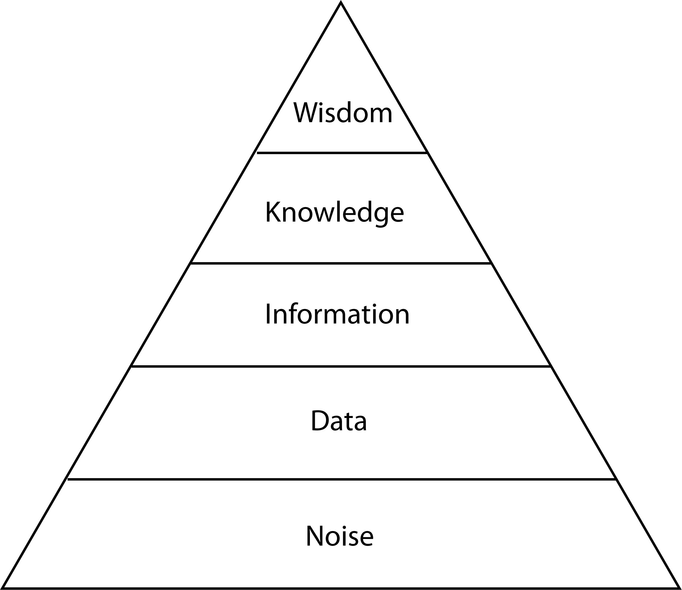
Figure 1. Progression of Economic Value and Valuable Intelligence (adapted from Pine and Gilmore, 2011).
There is a definite hierarchy of intelligence (in the sense of information of value) from noise, through data, information and knowledge to wisdom. At each level, what is available encapsulates what is known in the lower levels of the hierarchy, but makes what it more useful and usable, as well as more compact and communicable. The progression of useful intelligence (adapted from Pine and Gilmore, 2011, p. 275) is shown as a hierarchy in Figure 1.
The map has been an excellent spatial information communication tool for thousands of years, but the volume of information has grown to the point where it needs to be handled in different ways. Again, the volume of information is outpacing people’s ability to use it productively. So there needs to be a move to combine spatial information with other information about the real world to produce spatial knowledge. This tends to use processes like pattern recognition, rather than transformation, structuring and selection. One example of knowledge generation is the determination of cadastral boundaries, while another is data mining. In the 2010s, it could be expected that the term ‘Information Technology’ may start to be replaced by something like ‘Knowledge Generation’ in computing fields.
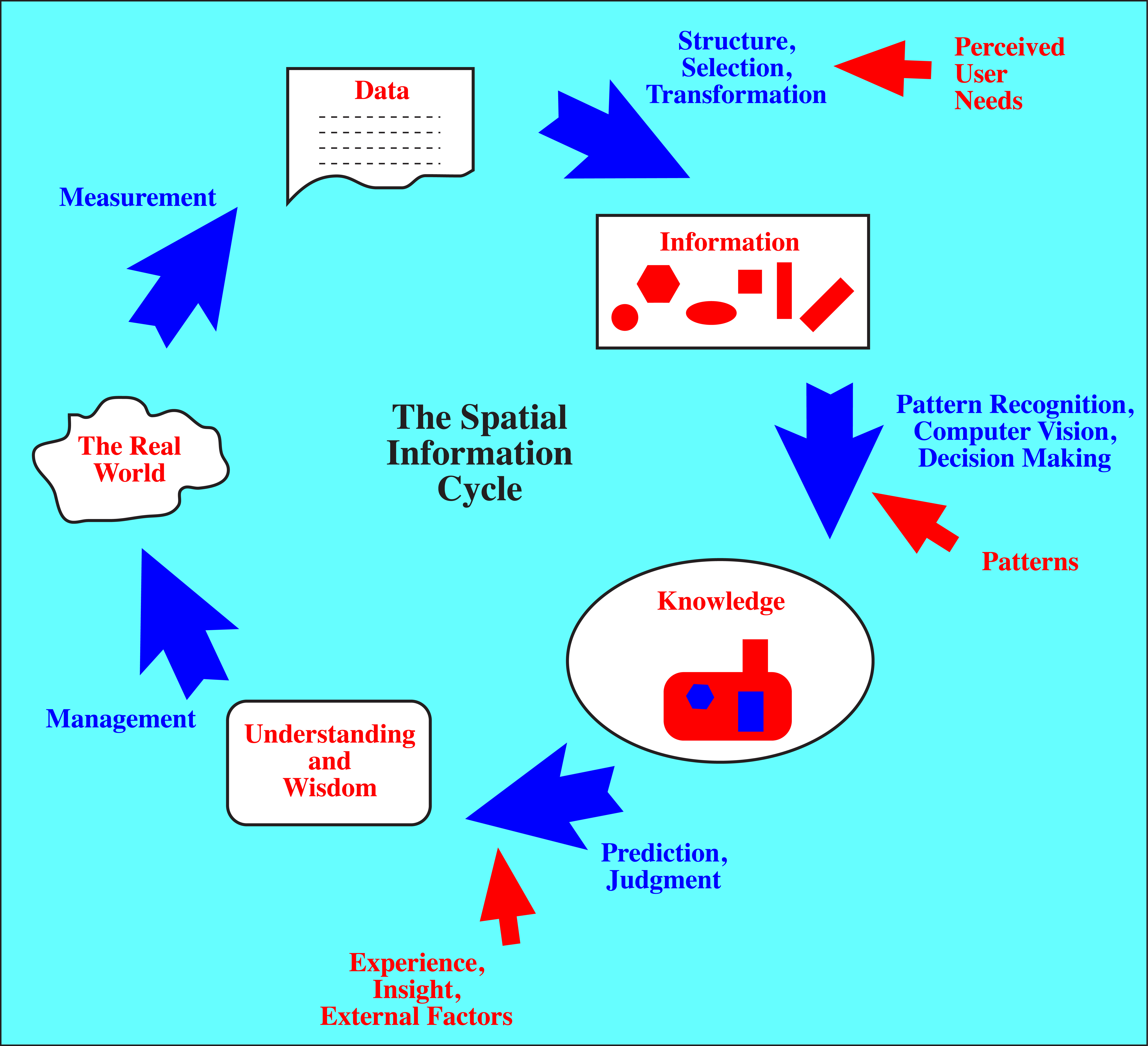
Figure 2. The Spatial Information Cycle (Hazelton, 2010).
Beyond spatial knowledge lies wisdom, but this is a more complex step. The spatial information cycle (Figure 2) is one method of interpreting this process, but in the near future there will need to be a greater emphasis on integration around the cycle. With this change, and the great increase in data volumes, will come an increased emphasis on data, information and knowledge management.
- Redefinition of the role of the surveying profession
In the rapid shift to GIS, remote sensing and data integration, the surveying profession risks being left behind, and becoming irrelevant in a rapidly changing world. That these changes will come to the details of boundary surveying is inevitable. GNSS is becoming increasingly precise, with improved GPS and multiple complementary systems becoming operational. South Australia has been investigating and working towards a co-ordinate based cadastre for over 40 years, and its results are starting to spread. LandXML is providing a basic format for integrating cadastral data into larger data sets within LIS/GIS. When measurement precision and aggregated records are sufficient to determine corners most of the time, there will be little need for traditional boundary surveys.
A critical change that has already taken place is the movement from physical measurement and data collection to what is now almost wholly electronic measurement and data collection. GPS, scanners, digital levels, digital cameras and total stations are now just ‘black boxes’ in which electronic ‘magic’ happens and numbers are produced that, hopefully, will mean something once they have been processed further. GPS static sessions are often processed over the Internet using OPUS, which automatically finds CORS, and the Internet is used for finding one’s way with Google Maps and Google Earth. These changes indicate that the core of surveying processes is already undergoing major change, as measurement becomes a remote, electronic process, and surveyors are more concerned with managing spatial information.
The impact of technological change has already affected a critical social aspect of surveying organizations. As technology reduces the field crew towards the ultimate goal of one person, the ability to train new recruits in the field is becoming progressively uneconomic. This means that field skills will have to be learnt elsewhere, changing the social relations within the surveying profession. This paper does not delve into the question of changing social relationships, but these are clearly being affected by changes in technology and technique.
So where does the surveying profession go in these difficult times? The final destination, and even the general direction, is less important than future-oriented movement, as remaining stationary will simply guarantee a permanent place in the past. Regardless of the direction, surveying needs to be redefined. If it is not done from within, it will be done from outside. This is already happening, as shown by court rulings concerning whether or not surveying in the USA is a profession.
Attempts to broaden what constitutes surveying in the USA over the past 40 years, such as by the creation of the term ‘geomatics,’ have tended to be met with a degree of hostility that was startling. The need for change is now being seen as an important topic within the profession, although the reality is that it is now both urgent and critical to long-term survival.
The easiest and most sensible place to start is with the profession’s strengths: cadastral knowledge, measurement knowledge, and legal knowledge. Building on these strengths can propel the profession into important roles in measurement integration and quality assessment, integrating cadastral information into larger knowledge bases, and ensuring the integrity of the cadastral system through coming changes.
7. Radical changes in higher education and the education of professionals
As the nature of knowledge changed during the Renaissance, the nature of universities also changed. Professions developed and the craft guilds mostly disappeared. As the nature of knowledge is changing today with the advent of huge quantities of digital information, so are universities changing. One of the most interesting recent events is that major private universities such as MIT, Yale, Harvard and Stanford, are providing a large amount of their course content materials free over the Internet (although this was preceded by some university level material being televised from the 1960s, e.g., the UK’s Open University, and the Sydney University School of Physics). This raises the interesting question of what these major universities consider to be the valuable thing that they are offering, if the course content materials are not considered worth selling.
Of course, the content has generally been available for a long time through textbooks, and more recently the Internet has seen Wikipedia and similar resources provide large amounts of the information found in such university-level courses. So these universities must have decided that they can be just as successful without having to sell the content. This signals a major change in universities, as well as the concept of education. If education is simply the accumulation of facts that can be recited on demand (the premise of proficiency testing in US schools, and the NCEES examinations), then education is now free to all, all over the world. On the basis of this model of education, no university could survive in this climate of free and abundant facts.
Universities are going to have to change their models of operation very quickly to deal with the advent of free, abundant and readily available course content. They are going to have to change what they offer, how they interact with students and how they deal with distance education. The digital revolution is changing how people learn, as well as what they need to know, and this will have a major impact on how universities work.
Educating professionals is also undergoing major changes. Several decades ago, students were predominantly full-time, came straight out of high school, passed by years rather than by courses (especially overseas), and usually graduated in four years. Now students come through multiple paths, work at least part-time, study part-time, and take longer than four years to graduate. This is as a result of changing social and economic circumstances. Distance education is also being requested, but it does not always seem to be as successful as desired, perhaps because of motivational and group issues, together with the realization that content does not equal education. Means et al., (2010) have reviewed the literature on many aspects of distance education and found that the benefits of distance education are limited compared to face-to-face teaching.
In the coming decades, higher education will change radically, as will the nature of professional education. There will be sharper definitions between technical and professional education, as well as more advanced, post-professional education. Professional education will be more flexible, but also more focused. Continuing formal education will become more important as technology changes even faster. The rapid changes in technology will require changes in how education is managed at the various levels, and greater emphasis on theory at the professional and advanced levels.
Conclusions
“Social relations are closely bound up with productive forces. In acquiring new productive forces, men change their mode of production; and in changing their mode of production, in changing their way of earning their living, they change all their social relations.” (Marx, 1847)
The punctuated equilibria model, developed by Eldredge and Gould (1972) and outlined and applied to the history of surveying in Hazelton (2012), fits well with the rapid and revolutionary changes that occurred primarily in the period 1550-1650 AD. That period of about 100 years of rapid change completely changed the surveying technology, methodologies, theory and worldview that had remained almost unchanged for over a millennium. It also fits well with the period of rapid change which surveying has been undergoing for approximately the last 65 years.
Since the 1550-1650 revolution, surveying has helped integrate numerous technologies, as well as drive theoretical developments in mathematics, astronomy, adjustment theory, economics and politics. The 1550-1650 period was truly a revolution, in thinking as well as worldview, technology, technique and theory.
From the progression of developments in the 1550-1650 surveying revolution can be seen parallel developments in the current geospatial revolution. Several new technologies were being quietly developed over time, and when they started to come together, the rate of change in surveying started accelerating from the background pace of the previous 300 years. The initial changes were largely focused on doing position location more efficiently and effectively. However, as more advanced technologies, such as GIS, laser scanners and digital photogrammetry, have moved into regular use, there have been much more significant changes in fundamental methods and concepts.
These changes have challenged the entire process of the production and dissemination of spatial information. Surveying has already moved away from measurement, as measurement is now an electronic abstraction. As the means of production change, so do social relations. The ‘digital revolution’ is changing social relations in ways beyond the scope of this discussion, but they will have a major impact on the geospatial disciplines and their associated professional organizations. This will include the ways in which professional education happens, and the way that universities work.
The US surveying profession is at risk because of the speed of change in technology, theory and mindset, and its slow rates of change and adoption of technology in the recent past. The changes of the last 65 years have been the just the starting phase, the warm-up to the real revolution. Greater and far more fundamental changes are ahead for the entire geospatial field. How these are tackled will decide the future of the US surveying profession.
References
Alder, K., 2002. The Measure of All Things: The Seven-Year Odyssey and Hidden Error That Transformed the World. New York: The Free Press.
Alexander, A., 2010. Duel at Dawn: Heroes, Martyrs and the Rise of Modern Mathematics. Boston: Harvard University Press.
Beadell, L., 1966. Too Long in the Bush. Sydney: Rigby.
Christensen, C.M., 1997. The Innovator’s Dilemma: When New Technologies Cause Great Firms to Fail. Boston: Harvard Business Review Press.
Eldredge, N., and Gould, S.J., 1972. “Punctuated equilibria: an alternative to phyletic gradualism.” In: Schopf, T.J.M., (ed.), Models in Paleobiology. San Francisco: Freeman Cooper. pp. 82-115.
Ferreiro, L.D., 2011. Measure of the Earth: The Enlightenment Expedition that Reshaped our World. New York: Basic Books.
Fitzherbert, A., 1523. The Boke of Surveying and Improvements. London: Pynson.
Hazelton, N.W.J., 2010. “Surveying: Beyond Mere Existence.” ACSM Bulletin, No. 244, April, 2010. pp. 36–38.
Hazelton, N.W.J., 2012. The Surveying Revolution of 1550-1650: Implications for the Current Geospatial Revolution—Part I. Surveying and Land Information Science, Vol. 72, No. 3, pp. 129–139.
Kass, R.E., 2011. “Statistical Inference: The Big Picture.” Statistical Science, Vol. 26, No. 1, pp 1-9. < http://www.ncbi.nlm.nih.gov/pmc/articles/PMC3153074/ >
Keay, J., 2000. The Great Arc: The Dramatic Tale of How India was Mapped and Everest Named. London: HarperCollinsPublishers.
Lu, Y., and Henning, K.S.S., 2013. “Are Statisticians Cold-Blooded Bosses? A New Perspective on the ‘Old’ Concept of Statistical Populations.” Teaching Statistics. Vol. 35, No. 1.
Marx, K., 1847. The Poverty of Philosophy. London: Martin Lawrence.
Means, B., Toyama, Y., Murphy, R., Bakia, M., and Jones, K., 2010. Evaluation of evidence-based practices in online learning: A meta-analysis and review of online learning. Center for Technology in Learning, U.S. Department of Education. 94 pp. Retrieved May 11, 2012 from http://www2.ed.gov/rschstat/eval/tech/evidence-based-practices/finalreport.pdf.
Pine, B.J., II, and Gilmore, J.H., 2011. The Experience Economy – Updated Edition. Boston: Harvard Business Review Press.
Rathborne, A., 1616. The Surveyor in Foure Bookes. London: W. Burre.
Stubbs, W., 1903. The Constitutional History of England, Volume I. Oxford, UK: Clarendon Press.
Werner, A.P.H., 1966–1968. “A Calendar of the Development of Surveying.” The Australian Surveyor, Vol. 21, No. 3, September, 1966, pp. 847-874; Vol. 21, No. 4, December, 1966, pp. 927-947; Vol. 21, No. 5, March, 1967, pp. 27-48; Vol. 21, No. 6, June, 1967, pp. 145-166; Vol. 21, No. 7, September, 1957, pp. 265-289; Vol. 21, No. 8, December, 1967, pp. 332-355; Vol. 22, No. 1, March, 1968, pp. 43-81; Vol. 22, No. 2, June, 1968, pp. 131-141. Also Letters, Vol. 23, No. 3, September, 1970, p. 212.