
Leveling and Vertical Location.
Volume 3 of Surveying: Foundation of Geomatics
by John D. Bossler
and N.W.J. Hazelton
ISBN 978-0-9961230-2-4
About 900 pages, including Glossary, etc.
Landscape Mode.
See the book's page in the Wollindina Media Store.
Viewable in a range of ePub Readers on Windows, Macintosh, iOS, Android, Linux and ChromeOS devices.
Price: $ 10.00 (USD, equivalent prices elsewhere)
Current Version: 1.0.0, equivalent to 1.0.5 in the iBooks version.
Other Variants
This book is also available Apple platforms as an iBooks MultiTouch eBook. See the iBook version's page here.
ePub Reader Software
We have tested the book on a number of platforms with a number of readers. For a discussion of different readers, see this page.
About the Book
This new textbook series for surveying and geomatics programs builds on the venerable Surveying text by Harry Bouchard, Frank Moffitt and John Bossler. It is a complete revision and restructuring of that book to take advantage of the latest textbook technology, and the latest advances in surveying and geomatics. Presented as an ePub3 Textbook, it includes video, animations, slideshows, full color text and figures (as appropriate), and hyperlinked text. Audio of pronunciations of certain terms has also been included. This volume, Leveling and Vertical Location, is a stand-alone textbook on its subject, but also fits into the series to provide a comprehensive overview of the discipline.
Primarily for students in surveying, geomatics and engineering, at 2-year and 4-year programs, it is also a suitable reference for educators, working professionals, and anyone who needs to understand vertical location. Designed to be easily read and understood, it has a strong practical orientation, while also including advanced topics. Videos show how to do field work; text and illustrations work through field work in detail; field note recording is covered, step by step, in slideshows that the reader paces. Readers can also add highlights, notes and bookmarks to the text, using the appropriate ePub Reader software. Colors have been optimized for color-blind readers. Some readers can read the text aloud.
While covering leading-edge topics (e.g., LiDAR, UAVs, Locata, digital photogrammetry, IfSAR), the historical foundation of current methods is included, together with the rationale for certain methodologies.
The book can be viewed a wide range of ePub Readers on a wide range of platforms. For more details about readers we have tested, go to this page.
Purchase entitles the buyer to unlimited free updates and use across all their compatible devices. Buy once: it lasts forever, through every update, big or small!
Book Design
There are many ways to slice a surveying curriculum. In this book, we have covered leveling from its most basic through to precise leveling. But we have also covered the very many ways in which the vertical location of a point can be achieved. This includes GNSS, photogrammetry, LiDAR and SAR, as well as older technologies. In one book there is not only material for the foundation surveying courses, but also material on more advanced material that builds on and connects with the foundations. So Least Squares Adjustment of leveling is covered, together with quality measures for many different technologies, the importance of rigorous checking, error propagation in leveling, and a wide range of other relevant topics.
Several full-page views are shown here, as well as a several small parts of pages, to give you a feel for the book.
Within the book, we have included several videos. In addition to the introductory video (check it out by clicking the menu item Intro Video), there are videos describing and showing how to set up an automatic level, how to remove parallax, how to do a two-peg text, and the basic leveling process.
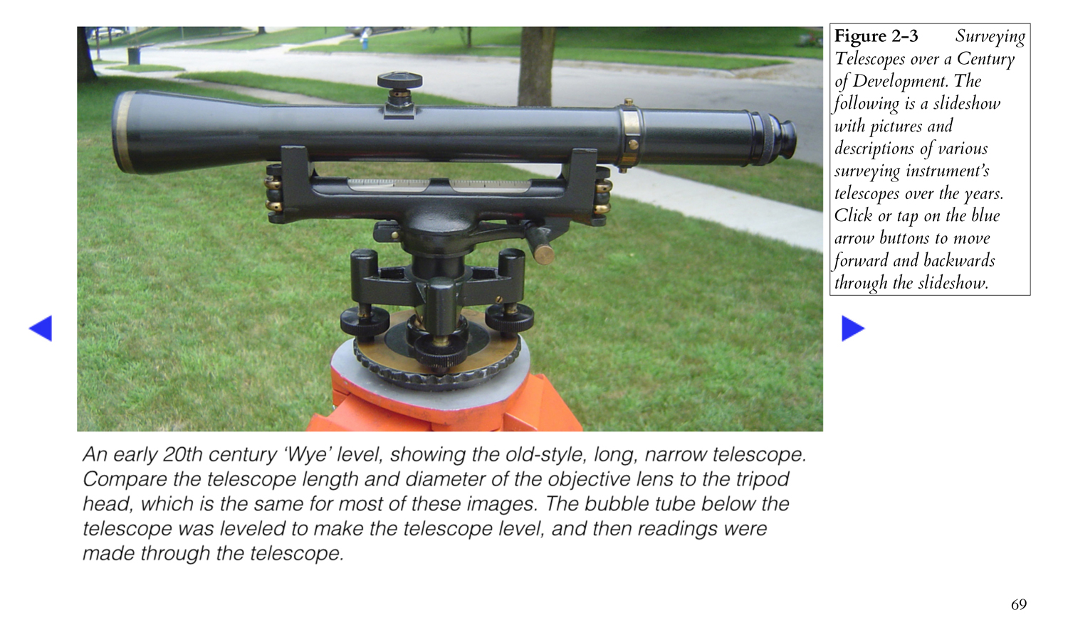
In order to take the student through the processes of recording and reducing leveling data in a field book, this is implemented in three slide shows, which guide the student at their own pace through the processes. Another slide show covers the development of and variation in surveying instrument telescopes over the past century.
Several diagrams are animated, although in the ePub3 version that are actually videos, so that the student can see how the item actually works. Bubble tubes, split-bubble reading systems, electronic level sensors, parallel-plate micrometers and micrometer in the Zeiss Koni 007 level are presented as animations, together with the operation of a vernier and the availability of satellites in the GPS constellation.
Color illustrations and photographs are used liberally through-out the text. The text is extensively cross-linked to form a hypertext document. An extensive glossary is available at any point in the book through links to the Glossary, as is search and a topical index. References are linked to locations on the Internet, where available.
Students can also take advantage of the fact that the underlying devices can usually run office applications, e-mail, web browsers and other educational support tools. This is usually all available in the one device, whether a desktop or mobile device. This allows the student to take a comprehensive computational tool with them, as well as their textbooks. Mobile devices allow video to be checked in the field using a compact device.
In the current version, the book contains the following:
- 200 (or more) color photos
- 14 back and white photos
- 92 color illustrations
- 52 black and white illustrations (where any color used wasn't critical to the illustration)
- 66 tables (some with color annotations)
- 8 animated illustrations
- 4 slide shows and
- 6 videos.
In the early versions of the books in this series, we have built in a number of features that are simply not possible in conventional paper textbooks. We see no reason to stop there, and are planning how to use the power of these computational platforms to advance technical and professional education in this field.
Instantiations
With an electronic book, the idea of an edition seems to become meaningless, as the book can be updated at any time, and the updates propagated to all previous buyers. One month after the book's initial release, we had already made four updates. So we are using 'Version' to describe these versions of the book, starting with Version 1.0.0 as the first public release.
There will be other volumes in the series, and these will be 'Volumes,' But what about the same book, tailored to different nations and readerships? In most parts of the world, metric measurements are all that are required, and different vertical datums are used in many countries. As a result, we are terming the same book tailored for different markets 'Instantiations.'
This instantiation is tailored for North America and written in English, hence it's the North American English Instantiation.
Because each instantiation is a separate book, with its own ISBN identifier, and they are tailored for specific markets, there is little point in buying more than one instantiation of each volume. So choose your instantiation carefully!
Table of Contents
Foreword
Driving Instructions
1. What You Need to Know First
Errors
Basic Statistics
Units
Distance Measurement
Traversing, Triangulation and Trilateration
Map Scales
Technology, Systems and Revolutions
2. Theoretical Matters
Basic Definitions and Concepts
Surveying Telescopes and Basic Optics
The Earth and its Impact on Vertical Location
3. Leveling Equipment
The Bubble Tube
Leveling Rods
Levels
Marks and Monuments
Tripods
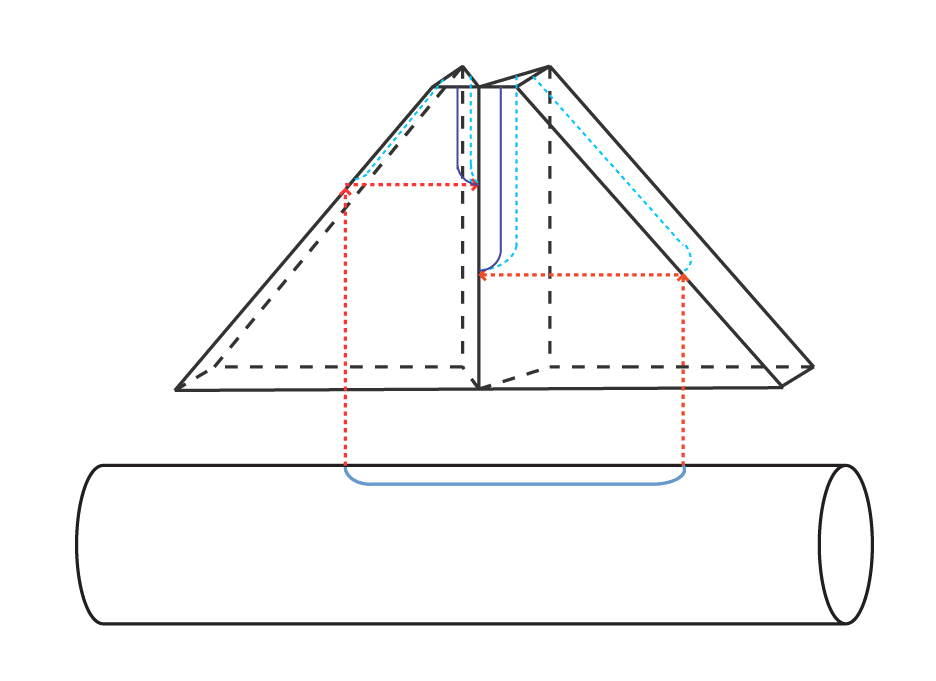
Optical Squares
4. Leveling Procedures
Fundamentals
Height of Collimation Method
Rise and Fall Method
Grid Leveling Method
Point Leveling
Line Leveling
Area Leveling
Additional Basic Field Techniques
5. Errors, Accuracy and Precision
Sources of Error
Error Propagation
Orders of Leveling
Closures and Misclosure
Precision and Accuracy of Leveling
Basic Checking and Adjustment
6. Other Methods
Water Level Methods
Trigonometric Methods
Tacheometric (Stadia) Methods
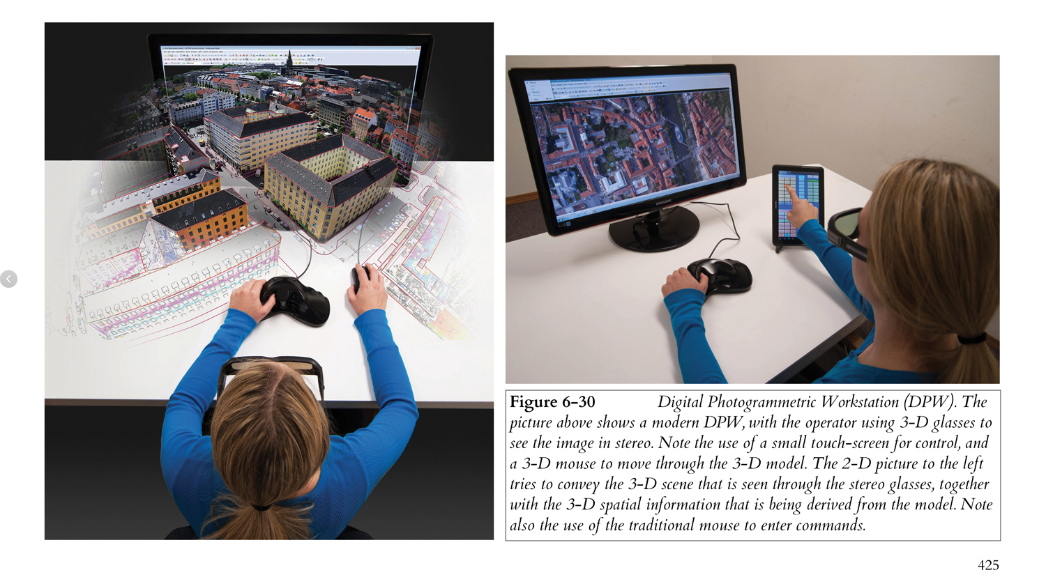
Photogrammetry, LiDAR and Similar Methods
Other Methods
Scale It From a Map
7. Advanced Leveling Topics
Precise Leveling
GNSS and Related Leveling
Other Radio-Based Location Systems
Least Squares Adjustment of Leveling
Vertical Positional Accuracy Standards
Appendix
Barometric Methods
Plane Table Methods
Pronunciations
Index
Topical Index
Table of Figures
References
Glossary